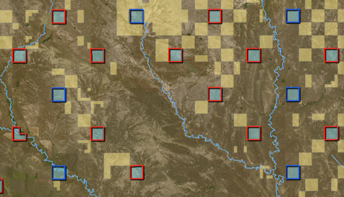
A new map that identifies every state-owned parcel in Montana confirms that nearly a third of the state’s school-trust lands are inaccessible to public recreationists.
Montana’s Department of Natural Resources and Conservation announced its new Trust Lands Public Access Map and mapping tools this week. It confirms, and visually represents, some of the data referenced in a 2019 report by the digital mapping company onX and the Theodore Roosevelt Conservation Partnership. That report also indicates about 1.5 million acres of Montana’s 5 million acres of state lands are inaccessible to the public, though it doesn’t specify which parcels.
On the DNRC’s map, accessible state lands are bordered in blue while inaccessible lands are bordered in red. While red squares can be found in all areas of the state, they predominate in central and southeastern Montana, where large ranches often surround state sections, which are often leased to adjacent property owners for livestock grazing or farming. The onX/TRCP report noted that across the West, some 6.35 million acres of state lands are “landlocked” and have no permanent legal access.
Montana DNRC’s new mapping tool is “designed to promote responsible recreation by getting important access information at the fingertips of users across the state,” according to an agency press release. “The mapping tool reveals use restrictions and any special scenarios that might impact public access, like a state section’s location inside an airport boundary or other restricted property.
The DNRC defines sections as publicly accessible if they are legally accessible by either walk-in access through adjacent public land or adjacent trust land or motorized access by a public road or designated open road. The agency defines publicly inaccessible as parcels that are surrounded by private land and “are not accessible to the public without permission from an adjacent private landowner to cross through their property.” The agency has denoted some parcels as “special scenario” that don’t have clear access. These properties might be accessible only through Montana’s Stream Access Law, have multiple parcels with different access types, or access status is unknown and requires more research.
The new map also has relevant resources like recreational use rules, stream access, fire restrictions, enrollment in Fish, Wildlife & Parks Block Management agreements, and a direct link to purchase a conservation license. The annual state conservation license is required to recreate on Montana’s state trust lands. The $8 license ($10 for nonresidents) is part of FWP’s annual hunting license, but other recreational users, including anglers, floaters, hikers, and horseback riders who use state lands can purchase the recreational use permit online or at any FWP office.
About 4.7 million acres of Montana state trust lands are managed for grazing, mining, timber, and agriculture, according to the DNRC, which in 2023 distributed some $46 million in lease fees to the state’s Office of Public Instruction to fund public education. That amount is a fraction of the roughly $2.1 billion the 2023 state legislature earmarked for K-12 public education in Montana, according to research by the Montana Free Press.
The status of both federal and state lands in the West are a hot political topic, as lawmakers in 11 states have signed on to a Utah lawsuit that could bring millions of acres of federal lands under state control. Wyoming, with 17 million acres of federal Forest Service and BLM lands, is the latest state to sign on to Utah’s suit that claims that “unappropriated” federal lands were never meant to remain under federal control. Proponents of divesting these lands claim that decisions about land use are better made by states “with their local expertise, greater stakes in the outcome, and greater accountability to their citizens.”
Read Next: The Largest and Least-Funded Public-Land Agency in America Is Finally Getting Backup
Opponents of land transfer claim that, because state trust lands are constitutionally required to generate revenue for states, that agencies such as DNRC might be required to sell lands in order to fund schools. Critics also argue that budgets in Western states aren’t sufficient to manage lands that are currently funded by federal coffers.
A clarification was made on Dec. 3, 2024: A previous version of this article stated that onX and TRCP “released” data about landlocked public lands in its 2019 report. In fact, the report did not identify which parcels were landlocked and the mapping company has not released that data to the public.
The post 1.5 Million Acres of Montana State Trust Land Is Inaccessible, New Map Shows appeared first on Outdoor Life.


