
Find Your Way – True Grid
A series of articles dedicated to the lost art of land navigation and map reading
By H-Minus
I am a big fan of old westerns. John Wayne and Clint Eastwood were the quintessential cowboys. As a kid, I would imagine being on horseback in the wilderness. Me and the Duke gunning down a bad guy, wanted for some unspeakable crime… I would spend Saturday afternoons watching a drunken, U.S. Marshal and his Texas Ranger sidekick tracking the murderer of a young woman’s father. Or a Sunday Spaghetti Western, with the trio: Clint , Lee and Eli (AKA The Good, The Bad ans The Ugly) attempt to find stolen Confederate gold. Something always bothered me about those movies… How did these guys know where to go?… There were no roads, at least not in the movies.. So how did they know what direction to travel and how did they know how to get back home? There are some people who have a great sense of direction… I am not one of them… Even with a map and a compass, I have a difficult time getting from point “A” to point “B”. Some of us not as directionally superior as the hero’s of those old westerns. We need help! The last article discussed the “Five major” and “Three minor” terrain features associated with a map. We also touched on “Grid North” versus “Magnetic North”. This article will discuss how to establish a grid coordinate as it relates to map reading. Maps typically have one of three ways to establish a location: Latitude and Longitude Coordinates:The geographic latitude of a point on the Earth’s surface is the angle between the equatorial plane and a line that passes through that point and is normal to the surface of a reference ellipsoid which approximates the shape of the Earth. The North Pole is 90° N; the South Pole is 90° S. The 0° parallel of latitude is designated the equator, the fundamental plane of all geographic coordinate systems. The equator divides the globe into Northern and Southern Hemispheres.
The Longitude of a point on the Earth’s surface is the angle east or west from a reference meridian to another meridian that passes through that point. Latitude and Longitude is displayed in degrees, minutes, and seconds. To be perfectly honest with you, I know very little about longitude and latitude.
Example:
 Universal Transverse Mercator (UTM):
The UTM system is a geographic coordinate grid-based method of identifying locations on the surface of the Earth. A position on the Earth is referenced in the UTM system by the UTM zone, and the easting and northing coordinate pair. The easting is the projected distance of the position eastward from the central meridian, while the northing is the projected distance of the point north from the equator (in the northern hemisphere). Eastings and northings are measured in meters. When interpreting a UTM grid you will read right (east) and up (north).
Universal Transverse Mercator (UTM):
The UTM system is a geographic coordinate grid-based method of identifying locations on the surface of the Earth. A position on the Earth is referenced in the UTM system by the UTM zone, and the easting and northing coordinate pair. The easting is the projected distance of the position eastward from the central meridian, while the northing is the projected distance of the point north from the equator (in the northern hemisphere). Eastings and northings are measured in meters. When interpreting a UTM grid you will read right (east) and up (north).
Example:
 Military Grid Reference System (MGRS):
This is the standard reference for the US military and NATO. It is also the one that I am most familiar. Unfortunately, USGS maps are not marked with MGRS. MGRS is derived from the UTM (Universal Transverse Mercator) grid system, but has a different labeling as that used by UTM. A MGRS consists of three parts.
Military Grid Reference System (MGRS):
This is the standard reference for the US military and NATO. It is also the one that I am most familiar. Unfortunately, USGS maps are not marked with MGRS. MGRS is derived from the UTM (Universal Transverse Mercator) grid system, but has a different labeling as that used by UTM. A MGRS consists of three parts.
- A grid zone designator, GZD. These are zones, numbered 1–60 and are intersected by latitude bands that are lettered.The intersection of a UTM zone and a latitude band is called a grid zone, whose designation in MGRS is formed by the zone number (one or two digits – the number for zones 1 to 9 is just a single digit, followed by the latitude band letter. This same notation is used in both UTM and MGRS. An example of a grid zone designator migh would be: “1Q” or 2”N”.
- 100,000-meter square identification. This is a lettered method of identifying a 100,000-meter square area of the earth. This is what most drunts pay attention to when goingoff map. The 100,000 – meter swuare identifyer, lets you know what the next map sheet will be. It is identified by letters. An example may be “FJ” or “AL”.
- The third part of an MGRS coordinate is the numerical location within the 100,000 meter square, indicated by numbers up to a 10 digit cordinate. A ten digit cordinate will give you a potential accuracy of up to 1 meter. The fewer digits, the less the accuracy. In the case of a 10 digit cordinate, The first five digits represent the easting in meters . The second five digits would represent the northing part of the cordinate.
Example:
 We will focus on UTM grid zone designators. Simply, because it is what 99 percent of us will encounter with maps originating from the USGS. You may remember from the last article that I spoke of maps that may not have grid lines marked. If you find that your map does not have grids, you can mark them with a straight edge, pencil, and steady hand. One thing to remember when reading a grid, is to always read the numbers from left to right and then up.
Example:
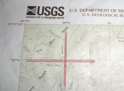
 If you notice the helicopter on this map, you will see it lies within a square or grid on this map. This grid is represented by two coordinates, or sets of numbers. One set of numbers goes from left to right as seen at the top of the image. The other goes from the bottom to the top as seen on the left side of the image. These represent the northerly and easterly grid lines as discussed earlier.
You will see the number 17 3 73 000 represents the easterly grid line for the helicopter. The three zeros at the end of this grid refer to 100 meter markings within that grid or box. Since we are not sure where the helicopter lies within those 100 meter boxes, we can leave the zeros off for now. We will get to those numbers as soon as we determine what grid square our helicopter lies in. So, we know that the helicopter is within the 17 3 73 easterly part of the grid, now lets determine what the northerly grid is.
Looking at the left side of the map, you will see a series of numbers going up in a northerly direction. This is the second half of your grid. In this case the helicopter lies in the 39 47 grid location.
If you notice the helicopter on this map, you will see it lies within a square or grid on this map. This grid is represented by two coordinates, or sets of numbers. One set of numbers goes from left to right as seen at the top of the image. The other goes from the bottom to the top as seen on the left side of the image. These represent the northerly and easterly grid lines as discussed earlier.
You will see the number 17 3 73 000 represents the easterly grid line for the helicopter. The three zeros at the end of this grid refer to 100 meter markings within that grid or box. Since we are not sure where the helicopter lies within those 100 meter boxes, we can leave the zeros off for now. We will get to those numbers as soon as we determine what grid square our helicopter lies in. So, we know that the helicopter is within the 17 3 73 easterly part of the grid, now lets determine what the northerly grid is.
Looking at the left side of the map, you will see a series of numbers going up in a northerly direction. This is the second half of your grid. In this case the helicopter lies in the 39 47 grid location.
If you put the two grid coordinates together you would have this:
17 3 73 E
39 47 W
You now have a grid location with 1000 meter accuracy, or as they say in the military “one klick”. A Klick is equal to a kilometer. Being the high speed land navers that we are, we want better accuracy than one klick. That is where our cool UTM grid tool comes in handy.
 This clear plastic measuring device will help us determine a grid coordinate to at least 100 meters. You can even get accuracy to 50 meters or less by simply making an accurate guess to points falling within the little 100 meter blocks.
Once you determine the grid square coordinates, you simply duplicate the routine using the grid tool. Remember to read right and then up.
This clear plastic measuring device will help us determine a grid coordinate to at least 100 meters. You can even get accuracy to 50 meters or less by simply making an accurate guess to points falling within the little 100 meter blocks.
Once you determine the grid square coordinates, you simply duplicate the routine using the grid tool. Remember to read right and then up.
RIGHT

THEN UP

GRID
17 3 73 650 E
39 47 400 N
Based on our calculations, we now have a grid location for the helicopter with an accuracy of at least 100 meters. It is more like 50 meters given the fact that our easterly part of the grid ends with the number 50. That pretty much covers the basics of obtaining a grid coordinate. For those of you who like to practice, there is a fun way to incorporate this into a cool hide and seek game. Find an easily obtainable location on a map, perhaps near a known road intersection. Hide a geocache near the intersection and give the grid coordinate to friends or family. Have them do the same for you. Use your new found map reading skills to find the cache and recover the items. As you get more skilled, look for local Geocaching clubs and find more difficult caches. I still wonder how cowboys made it around the wilderness without these tools. Were they so geographically inclined, they didn’t “need no stinkin maps?” Or was the map and compass a dirty little secret kept in saddle bags of cowboys everywhere? Well all cowboys except for Big bad John and Dirty Harry.Keep your powder dry.