We all know how absolutely important it is to take good care of your load bearing life dependant ropes are. Whether you use the for climbing rock faces & trees, effecting a rescue, or descending steep faces or even hills; it’s imparitive to take good care of them.
Having vast experience spanning decades in climbing & rescue I thought I’d share some tips for taking care of your ropes, and specific technique I’ve been using for ages and absolutely love when it comes to protecting your anchors from abrasion.
General things to look out for
Stepping on ropes – you never want to do this as you could press dirt, debris into the rope weakening it as well as cause an abrasion against a sharp rock beneath the rope.
Dirt is the enemy of a long life for ropes as it winds up between the fibers and sheathing and causes wear. When you have you ropes laying on the ground try using a tarp, shirt, pack or something to isolate it from the ground is the situation allows for it
Sun Damage – leaving a rope out in the sun can and will break down the fibers. Ropes are not made to be left out in the sun and can be damaged by UV rays, it will fade, dry and effect your rope longevity
General Rope Care
Make sure you know what kinds of ropes you have Static or Dynamic, and their manufacture ratings as for one to retire them based on number of falls, type of loads placed on them etc.
Store your ropes in a cool dry place. Do not leave anything sitting on top of them
Before and after every use of your rope you need to inspect it! Whether this takes 1 min or 10 mins your life depends on it and all ropes need to be inspected for abrasions, cuts, or any sort of damage. Go through every inch of the rope squeezing it between your fingers also trying to feel for any possible interior fiber damage
It’s a good idea to wash your ropes once in awhile to clean out any dirt particles. Do not use any harsh degreasers or chemicals. Use luke warm water with a mild detergent like Dawn. You can do this in a bathtub, buckets, troughs etc. Dry them out in the open air out of sunlight and uncoiled, do not use any sort of heat.
So now that we got the rope care basics out of the way I wanted to share a little trick I’ve been using for many years. If you climb, rappel, descend hills etc alot you’ll probably have some pre made up anchors. You can never have enough good rope anchors, as you’ll find yourself in many different situations and different distances from your edge. Personally I always use a minimum of 2 anchors and often 3 if one is a little shady i.e rock or bush.
My anchors get ALOT of use, and this is a trick I picked up decades ago, and I love it!
The best way I have found to protect and add life to my anchor ropes is to take a piece of tubular webbing and slide it over my anchor rope. It doesn’t have to cover the entire thing but just where it will be in contact with the tree, rocks, bushes etc. I’ve yet to have any wear and tear on any of my anchors using this method.
Amadou is a spongy, flammable substance prepared from Fomes fomentarius, also known as Horse’s Hoof or Tinder Fungus. Ötzi, the 5,000 year old Iceman, was found to have had amadou as part of his belongings. It was a valuable resource to ancient peoples like Ötzi as it could be used to catch the sparks from flint and iron pyrites or used as a coal extender. Amadou would often be processed, pounded flat, and boiled in a solution of Salt Peter to add to its flammability but will work just fine if found and extracted dry from the Tinder Fungus as a coal extender.
Other uses for amadou include felting as amadou was once used to make hats. In more modern day use, amadou is used to make artificial flies for fly fishing. Amadou may also be felted into pouches or similar products. It’s best to use it for something that will not be treated roughly as it is not the toughest substance. That is enough digression for now; what I want to talk about is Amadou, nature’s char cloth!
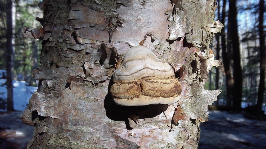
This is Fomes fomentarius, the tinder fungus.
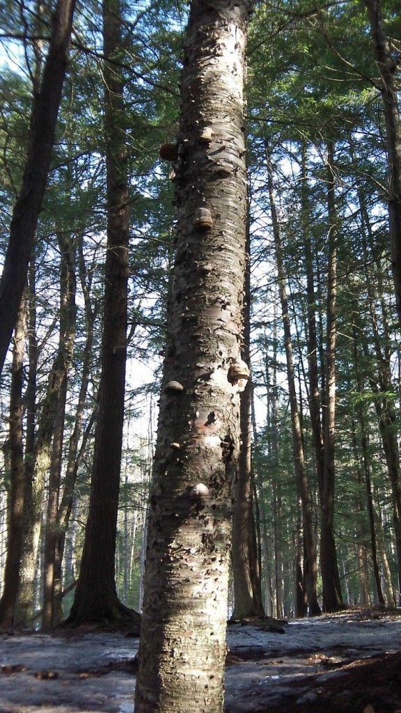
I most commonly find it growing on dead and dying birch trees. They tend to grow in clusters dispersed over the birch and are easily spotted from afar.
Here is what a birch tree riddled with tinder fungus looks like at a distance
As you can see by this photograph, tinder fungus is a polypore. This means that, unlike some other mushrooms, this mushroom lacks gills but has tubes or pores all over the bottom of which it disperses its spores.
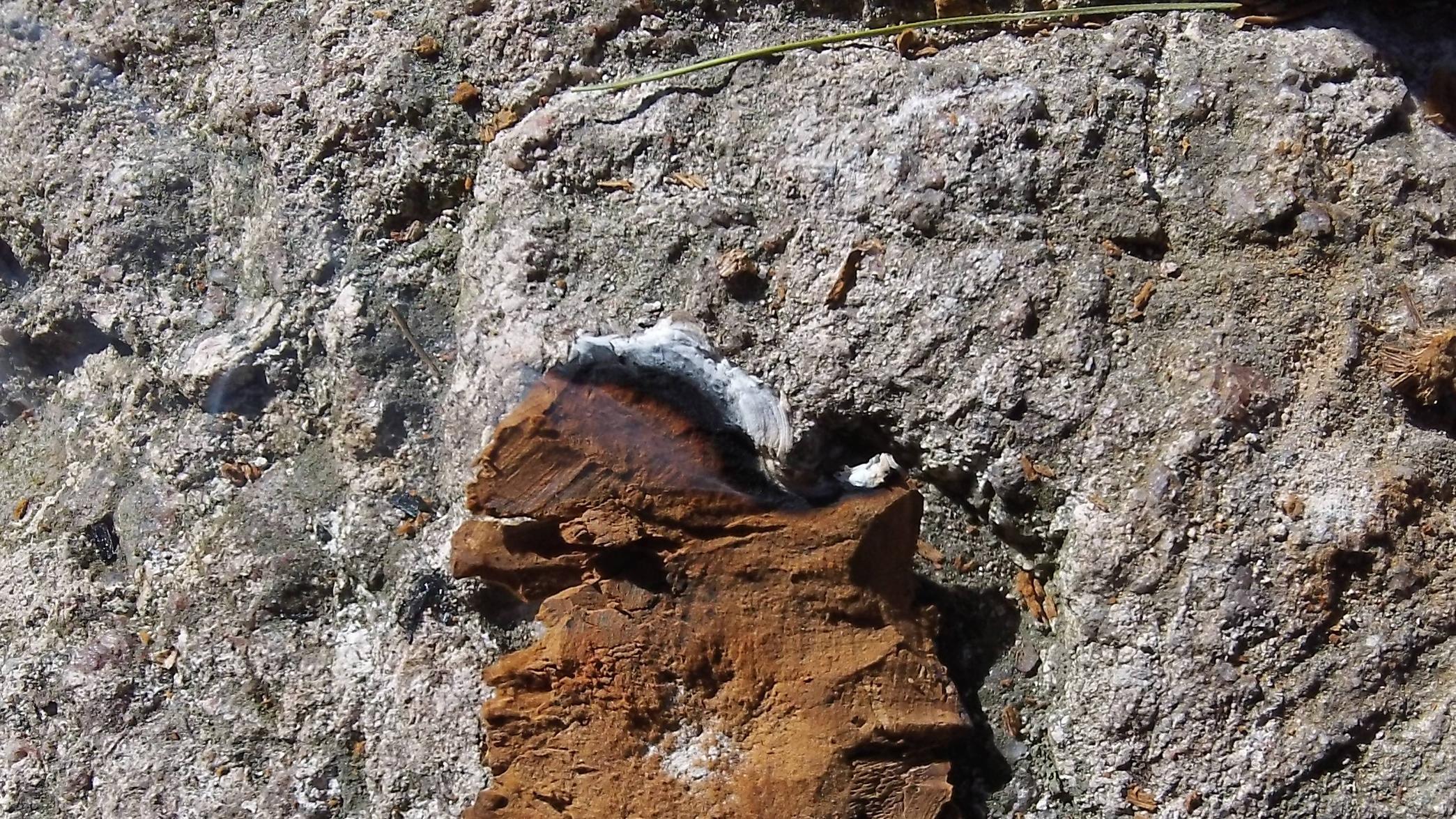
Often times it may take a good whack from a log or a hatchet to sever the tinder fungus from its bond to the tree. Once the fungus is removed the backside and some of the brown spongy amadou is visible. The brown corky textured substance in the middle is part of the natural char cloth known as amadou.
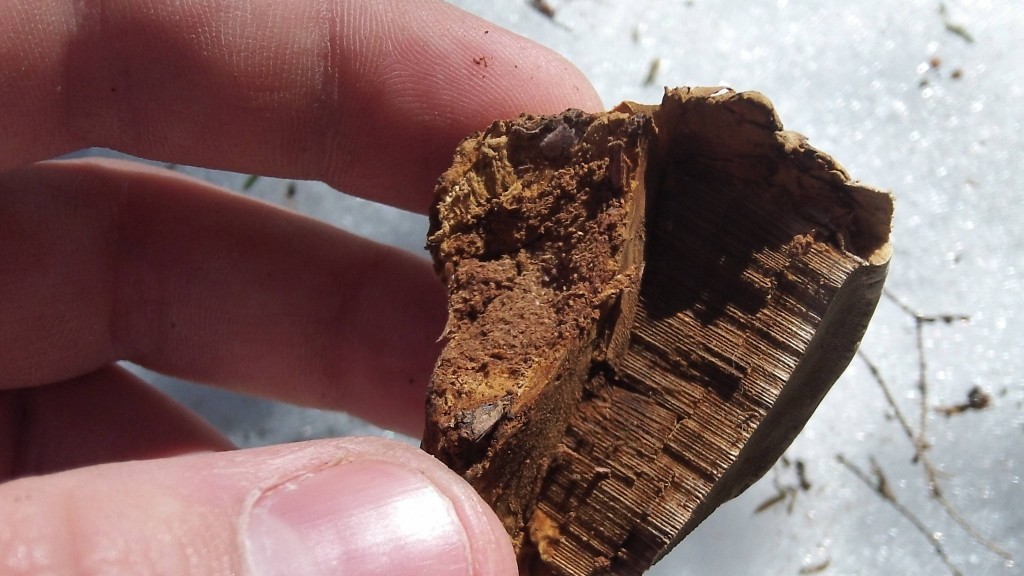
The extraction process is fairly simple. All you need is a sharp knife and to pay attention to the layers of the fungus that you are carving. The amadou is found just below the outer “shell” of the mushroom and just above the inner core of pores.
A shallow cut reveals the brown, spongy, natural char cloth material.
The light brown substance is what you are trying to preserve. Cut off the darker brown as that is still part of the outer “shell” of the fungus.
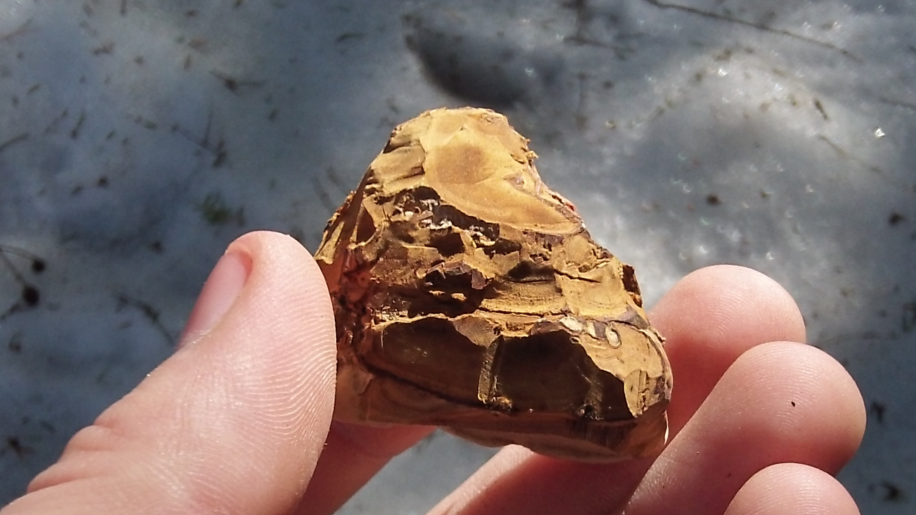
Here is a cross-section of the pores. This porous part of the mushroom is not what you are after when extracting amadou. It should be cut from your extraction if any is found hanging on to it.
When you have delicately removed the outer shell you should be left with something that looks like this:
Now, delicately remove the first few centimeters of the spongy substance with your knife. It is a very shallow cut to remove the amadou. When you have completed the cut, it should result in a thin felt or leather-like sheet.
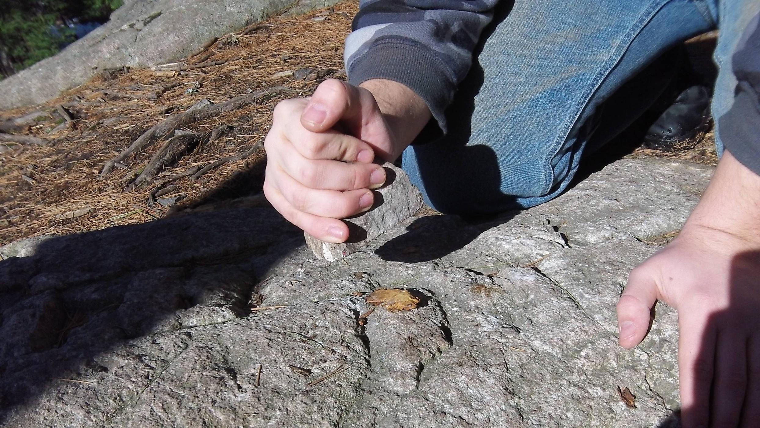
From here it will be necessary to increase the surface area of the amadou. To do so, one beats it with a rock until it is of proper flatness (which takes a little experimenting to get it just right). This also helps rough up the surface giving it even more surface area to catch a spark from a flint and steel or even a ferro rod.
After pounding out the amadou it should take on an even more felt-like nature.
It is now ready to receive a coal or be spark with a flint and steel. The only better thing to do is boil it in a solution of Salt Peter but that is an added and more complex step I will not be discussing in this article.
A flint striker and a sharp edge of quartzite which I dug out of the mountain should work nicely to spark the amadou
Here it is with a nice smolder going. I had timed this single piece of amadou smoldering and it had burned for just over 20 minutes. That is long enough to have a coal and build a new fire or to find and add it to a new piece of coal extender.
The amadou burned very hot. As it got smaller it became unbearable to hold it. To remedy this, one simple may place it on a gathered rock and continue on their way making sure to shield it from the wind lest it blow away.
All that would be needed is to place the smoldering amadou into a dry tinder bundle and blow it to flame for one’s fire to be preserved.
If you have ever been out in the bush on an extended trip then you know how useful being able to tie things down or lash a piece of gear to your pack truly is. From shelter, to fishing line, snares, to tying one’s shoes, rope is a very important part of everyday wilderness living. Carrying cordage into the bush is one way to make sure you have it but that luxury may be exhausted, be lost, or degrade over time.
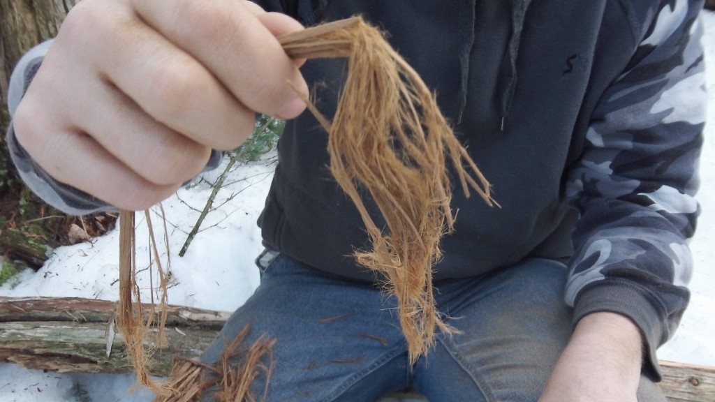
What I mean to do today is discuss and teach a method of making cordage from natural materials found all around us. Many materials will work for use in the reverse wrap method that I will be showing. Human hair, cattail, cedar, dogbane, and willow are some very common plants that have exceptional strength and easy use as cordage. The material I will be using for this tutorial is cedar from a fallen tree. While cedar is not the strongest material, it is readily available yearlong and may be doubled up to produce even stronger cord.
The first step is to find suitable material for producing cordage. Any fibrous material can be used. The First People would remove large sections of bark from a standing cedar tree to produce all sorts of materials from which cordage was only one tool of many.
This is a Northern White Cedar
When in dire need, a sheet of bark could be removed from this tree without killing it. For our purposes I located a down and dry cedar.
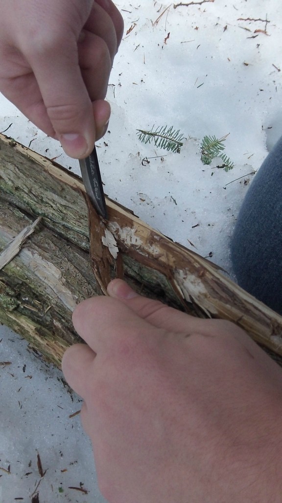
I begin to separate the bark from the hardwood by using my knife to pry it up and sliding the knife down the log
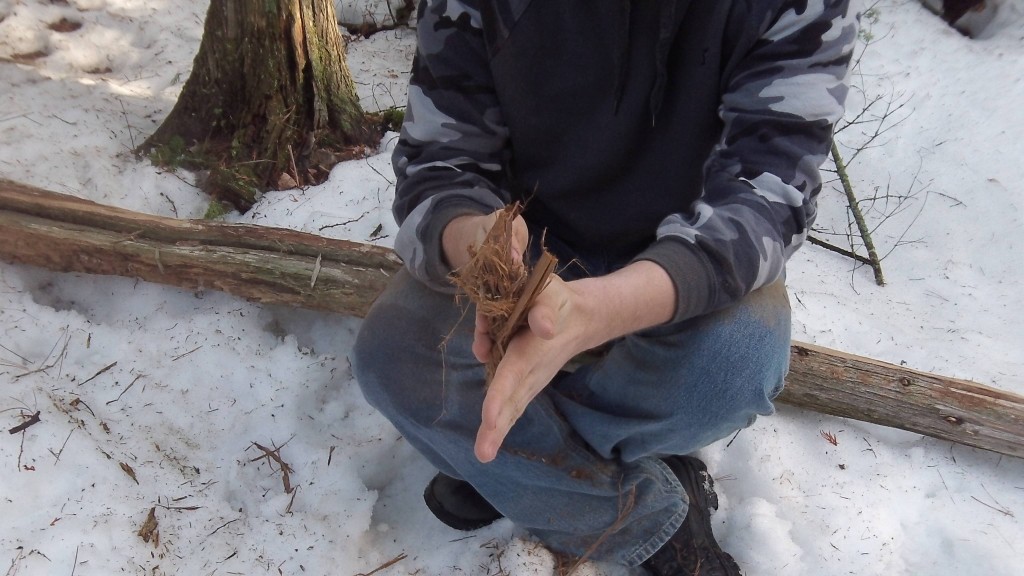
After enough cedar bark is collected, it must be processed. This is done simply by breaking it up in your hands and rubbing it back and forwards between your palms.
After thoroughly processing, your cedar should come out very fibrous and similar in texture to that of rough cotton.
Once the fibers are processed, and any hard bits of wood or outer bark are removed, it is time to begin making the cordage. Separate the amount of fiber desired with more fibers producing a thicker rope and less fiber producing a thinner rope.
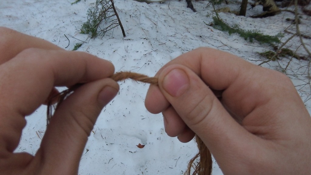
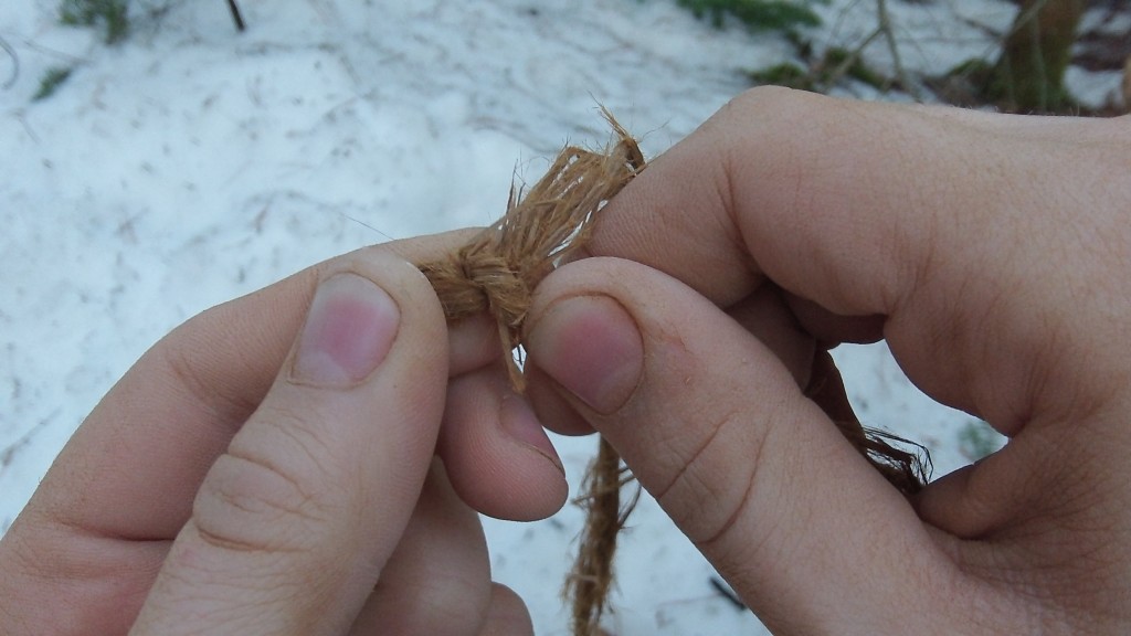
Hold the fibers between your forefingers. Rotate the fibers away from you with your right hand and towards you with your left hand until the cord becomes taut and kinks over.
Hold the kinked portion between your left thumb and forefinger.
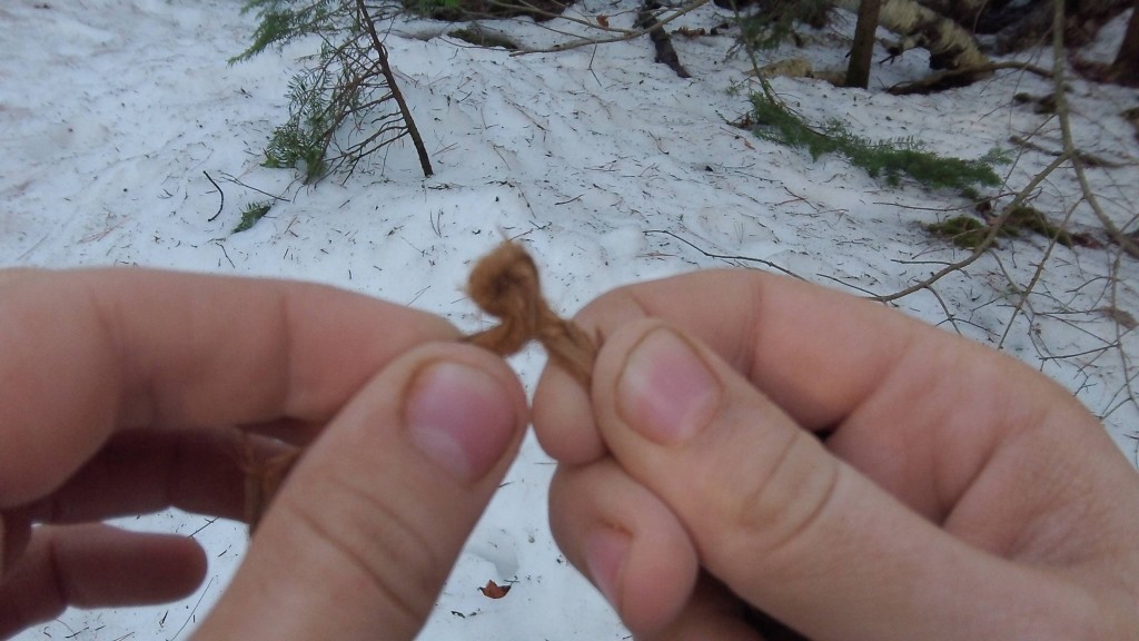
Now for the reverse wrap portion of this process. The top strand needs to be twisted away from your body with your right hand while your left hand stays stationary.
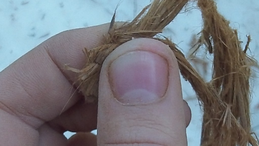
Pull the top strand towards you over the bottom strand.
After that step, pinch the formerly top strand with your left thumb to hold it in place.
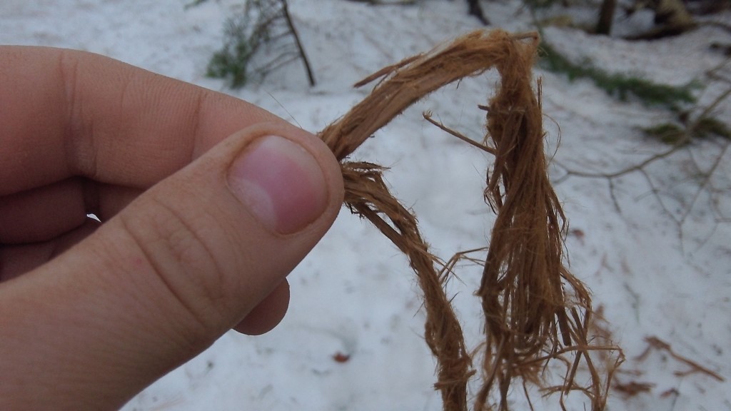
The process continues with the twisting away of the new top strand, pulling it towards you and down, and then pinching it once again. This continues until the piece of material becomes a bit too short.
When the material becomes too short, it is time to splice in more material. It doesn’t have to be made of the same material that the cordage was started with but in this case it is. It may be beneficial, at times, to use the same material so that a consistent strength can be expected throughout the cord.
To splice more material into the cord, pick up the amount desired to be spliced. Keeping the cord even throughout is the tricky part. When splicing, it is advised to splice a piece with one end longer than the other. This will help build strength within the cord.
Place the new strand in the crook of the old piece of cordage, making sure one end is longer than the other.
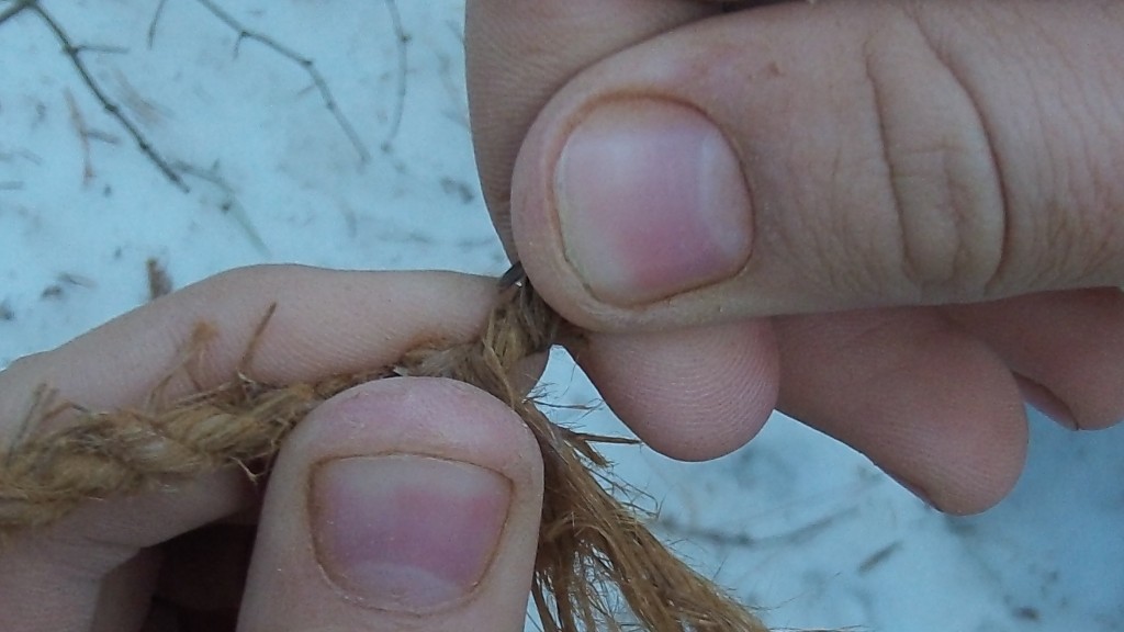
From here begins the same old process. While holding the new strand to the crook of the cord, twist the top strand away from you.
Pull it down and over the bottom strand.
Then, pinch it off with your left thumb and forefinger.
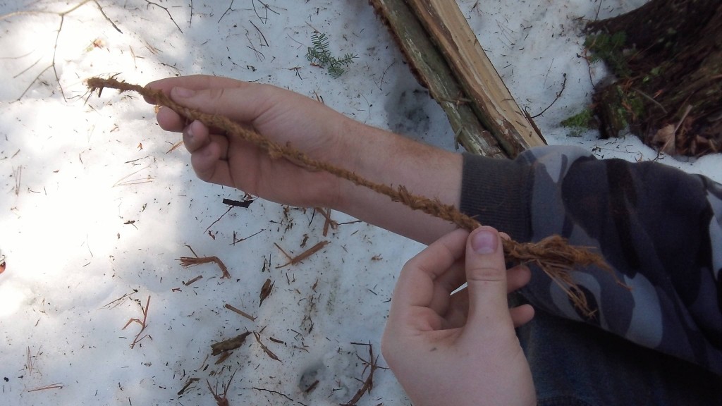
Continue the original steps once the piece is spliced in until the cordage reaches the desired length.
Just about any fibrous material can be made into cordage with the proper technique and treatment. Here is a list of other tried and true plants for making decent cord:
Cedar (inner bark)
Juniper
Basswood
Tulip Poplar (inner bark)
Willow (inner bark)
Mulberry
Elm
Dogbane (Indian Hemp. STRONG rope)
Stinging Nettle
Velvet Leaf
Whole leaves with shoots and fronds:
cattail leaves (strip down so it is thinner)
Blue Flag Iris
Lily
Saw Palmetto
Yucca
Grape Vines
Virginia Creeper (is a weaker material)
Thought I would share some of my fav Winter Survival Tips & Tricks
Winter is one of the harshest seasons of all, but yet it’s on of my favorites! If properly prepared it can be one of the most beautiful, peaceful and enjoyable.
So get out there and enjoy, just be safe & PREPARED
Eat a large dinner before you go to bed. The human body is essentially a furnace, and digesting calories generates heat, carbs are the best
Stay warmer longer by elevating your internal body core temps, get out and go for a quick brisk hike before hitting the sack
Wear a beanie to bed, while science has proven that we don’t loose 80% of our body heat through our head like previously thought, it’s more like 7-10%. It’s it’s still a good idea and an easy way to retain some body heat
Bring a Pee Bottle to bed, nobody wants to get out of their warm sleeping bag in the middle of the night and lose heat just to pee. Just Make SURE you have this bottle specially marked or identifiable in the dark, i.e something taped to it.
To keep your water bottles from freezing place them in a wool sock or something insulated, also I like to stash a couple of mine in the foot of my sleeping bag
Another tip to keep your water bottles from freezing is to turn them upside down, water will freeze at the bottom of the bottle first now
If you are melting snow for water, put a small amount of water in the pot first to keep from “scorching” the pot before the snow starts to melt
Absolutely avoid cotton if you can, once it gets wet it’s about useless for retaining heat, infact it will do more harm than good with wicking action
You can’t have enough extra pairs of dry socks. Wool blend is imparitive in the winter, I will often double my socks for warmth and to prevent blisters
Don’t forget the gloves, I usually have several pairs because they are so crucial yet easy to lose. We often take them off for moments of needed dexterity, so try a tether so as not to l
When setting up a camp site, think about wind protection, avoid high ridges
In snow it’s often hard to use stakes to anchor a tent, try filling bags or sacks with snow or rocks and burrying them in the snow
Ground insulation is almost more important than what you have on top of you, the more ground pad and insulation you have the warmer you will be
When setting up a winter campsite pack down any snow as best as you can, and dig down into the snow a couple feet if possible the snow will act as a barrier to wind & help retain heat
Remember the loft in your sleeping bag is what traps air and insulates, so loft/fluff your bag before bet time
One of my fav tips is before you go to bed boil water and fill a nalgene bottle with it. Place it in a sock and in the foot of your sleeping bag, it will keep you warm most of the night as the feet won’t require as much blood and heating
Avoid drinking alcohol,while it may burn going down it does nothing to keep you warm, infact it thins your blood making you colder.
Snow usually contains between 10-40% water by volume, making melting it for water inefficient. Ice if available is a much better option
If you must melt snow for water, put some water in the bottom of the pot or container first to prevent scorching the pot and the snow
If you are intentionally heading out into the wilderness in Winter, then try and bring a insulated thermos of hot soup or drink to keep you warm and your spirits up
If you enjoy learning about & talking Survival & Preparedness be sure to jump on our very active forum full of great tips, info and like minded people Survival Forum
The power has been out for the three months. No one knows what happened. The stores ran out of food after the first week. The water stopped flowing soon after that. Many large towns and cities are becoming uninhabitable. There is no law and no one to call for help. There is talk of terrible atrocities being committed by armed gangs.You are lucky, your town happens to be remote enough and small enough to manage the chaos. Folks from all walks of life are pulling together to make the best of this difficult time. An ad-hoc committee was elected to represent the town and you have been asked to help with security. Agreements were made to help a local farmer protect and harvest his crops in return for a share of the food. You have one problem. Although you have a decent security program, you worry about using the handheld radios. A few nights ago, one of the checkpoints could hear some chatter on the same frequency. Your radios are not the expensive ones with “secure” frequencies. You worry that if you can hear others, then others can hear you. Some of the information passed to shifts is sensitive to the security needs of the community. How do you pass on information without risk of interception?Today, you were discussing the possibility of bad guys listening in on your conversations, when someone mentions cryptography as a solution.Now the old days in the military started flashing in your head… yes… we had this thing called a CEOI (Communications-Electronics Operating Instructions). This person claims you can use a variation of the Vernam Cipher. A Vernam Cipher allows for the substitution of a plain text message with a random series of text or numbers from a “One Time Pad”. The resulting encrypted message is secure enough to be sent over the airwaves, without risk of being deciphered by an interceptor. Once it reaches its destination, the intended receiver will use the same “One Time Pad” to “unmix” the message. A true Vernam Cipher, if used properly is thought to be unbreakable. The reason is because the cipher key constantly changes. This randomness makes it very difficult to decipher. A poor mans version of this type of cipher can be something simple like a book. Each person intending to receive the secret message uses the book as a tool for decryption. As long as the bad guys don’t know that you are using the book as a tool, you should be secure. Lets say you wish to send the following message over the radio to a friend:
GET BACK TO THE BUILDING
Using a book as a “One Time Pad” you simply look for each of the words in the book. As you find a word, note the page number, line number and word number in the line. For simplicity, we will choose words all on the same page. “GET BACK TO THE BUILDING” encrypted will look like this:
11-1-25 / 11-32-8 / 11-1-10 / 11-8-2 / 11-7-7
The first three numbers (11-1-25) indicate the word you are looking for will be on page 11, line 1, and word 25.You simply conduct this find and replace operation with each sequence of numbers. What you end up with is a message.
“Get back to the building”
Although this type of cipher is not a true Vernam Cipher, it will work as a field expedient method of secure communications. That is unless the bad guys find out what you are using for encryption. To keep them from figuring this out, never mark inside the book or leave any trace of encrypted messages in the book. If any of these clues were left in the book, it wouldn’t take much for the bad guys to figure it out.The next article will dicuss a slightly more difficult, but secure version of the Vernam Cipher.
A series of articles dedicated to the lost art of land navigation and map reading
Determine your pace count
By H-Minus
Our last article discussed how to determine distance and direction on a topographical map. We touched on map scales, the difference between grid north and magnetic north. We even did a little bit of basic math…
Oh how I hate math…
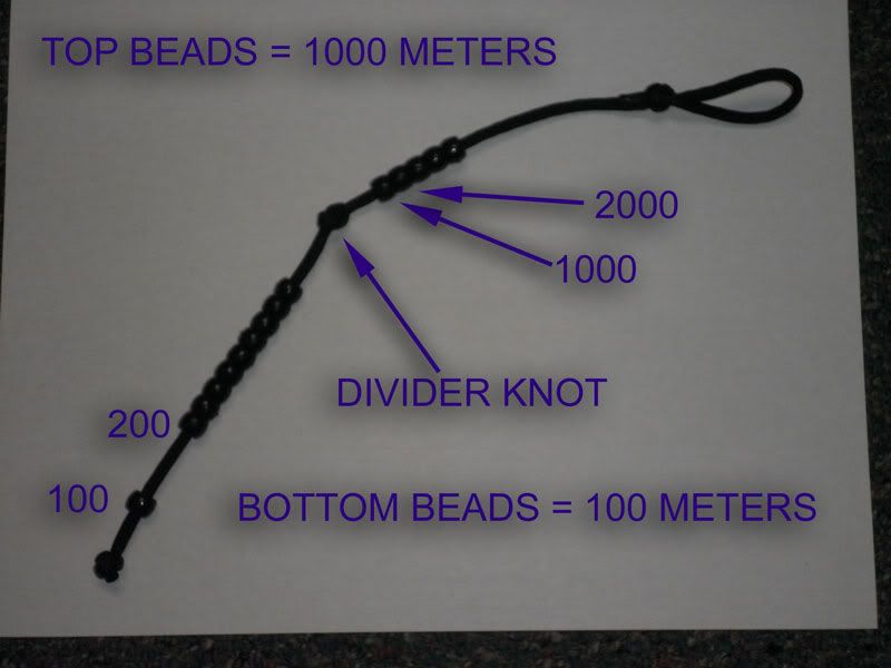
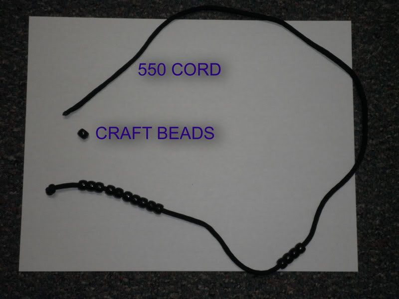
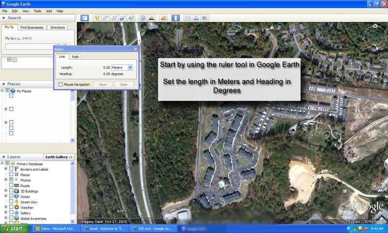
This article will provide you with some tips and tools to help you determine distance by the number of steps you take. It is called a pace count. If used in conjunction with other land navigation skills, it can be a pretty accurate way to determine distance traveled in the woods. Many things can determine the way you walk. Age, fitness level, height, weight, ground conditions are just a few. To establish a pace count, one must try to simulate as many of these variables as possible. For instance, if you expect to do most of your land navigation with a pack on, then it stands to reason that is how you should determine your count.It has been 28 years since I first walked the line to establish my pace count. When I started writing this article, I decided that it was time to see if it still the same. At 46 years of age, I might be in for a little surprise. Don’t get me wrong, I am in pretty good shape. I just think that back in the day, I spent more time in the bush than in the rear. I was more at home in the woods and it likely showed in how I moved. Now I might be a little more cautious when stepping over rocks, or crossing a stream. So, this summer, my goal is to establish a new pace count. Some of you may already know that soldiers and marines sometimes had two types of pace counts. One was a regular count for normal terrain and the other was what we called our Jungle count. Mine was discovered while attending JWS in Panama back in the early 80’s. We adapted that count for very difficult terrain. I don’t use it these days, but it is an option.The typical measurement for a pace count is in Meters. The equation goes like this (X = number of steps in 100 Meters). For me X=120. For every 120 steps (counting every step), I will have traveled 100 meters. If you remember in the last article, we determined distance on a map in meters. In fact, I believe the distance we determined on our map was 3400 meters. WOW! How many steps is that. Let’s see… 120 x 10 = 1200 steps in 1000 meters, then multiply 1200 times ???…. Oh forget it.. there is no way I can count that many steps.Lets try a different approach to recording your pace count. There is a handy little tool that you can easily make and will help you remember your count for several thousand meters. It is called a Pace Cord. It only requires a little 550 cord, some craft beads and a lighter. The typical Pace Cord has two sections. The upper section has several beads separated by a knot leading to the lower section. The lower section has more beads. The beads on the top of your cord represent 1000 meters for each bead. Each bead on the lower section represents 100 meters. As you count your steps and reach the 100 meter mark, you will move one of the beads on the lower section down. Once all the beads on the lower section are in the down position, you will move one bead from the upper section down. You will then move all the beads on the lower section – up and start over. There is some debate over how many beads should be on the bottom, but let’s simply use 10 beads.
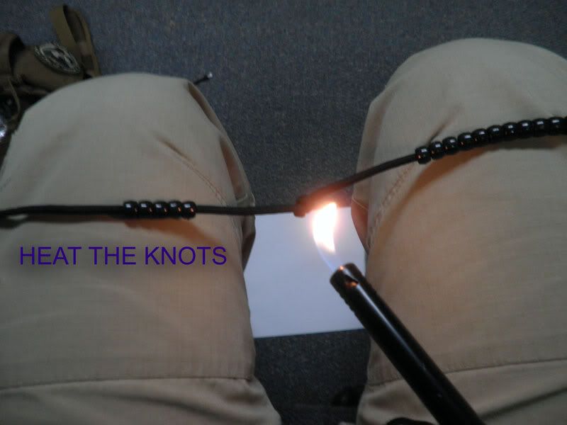
Constructing your pace cord is very easy. Get out your handy 550 cord and cut a small section to take to the craft store. Find the bead section and look for the type and size you would like to use. Make sure they slide on to the 550 cord with some resistance. You don’t want them moving about while you are in the woods. I placed 15 beads on my length of 550 cord. 10 beads for 100 meter increments and 5 beads for 1000 meter increments. Tie a knot on the bottom of the cord and use a lighter to lightly burn the knot. This will keep it from loosening up. You will then separate the beads into tow sections. 10 on the bottom and 5 on the top. Tie a knot between the beads and leave some room for bead movement. Heat the knot, tie a loop at the upper end and heat it too. Now you have a working Pace cord. You can attach this anywhere you wish.The next step is to find a place to count your steps. A good rule of thumb is to walk a known distance over 100 meters and count each and every step. Let’s say you plot a 400 meter route and count each step. At the end of your travels, you simply divide the number of steps by 4 and you have an average pace count for 100 meters. For those of you with a GPS, all you would need to do is set a starting point with the unit, walk several hundred meters using the device and do the math. Most GPS units will show you distance traveled. Use that to record the number of meters. Another way is to use Google earth to plot a route, walk the route and record your steps.
Google earth is a great tool for navigation and reconnaissance. You can download the program for free at:
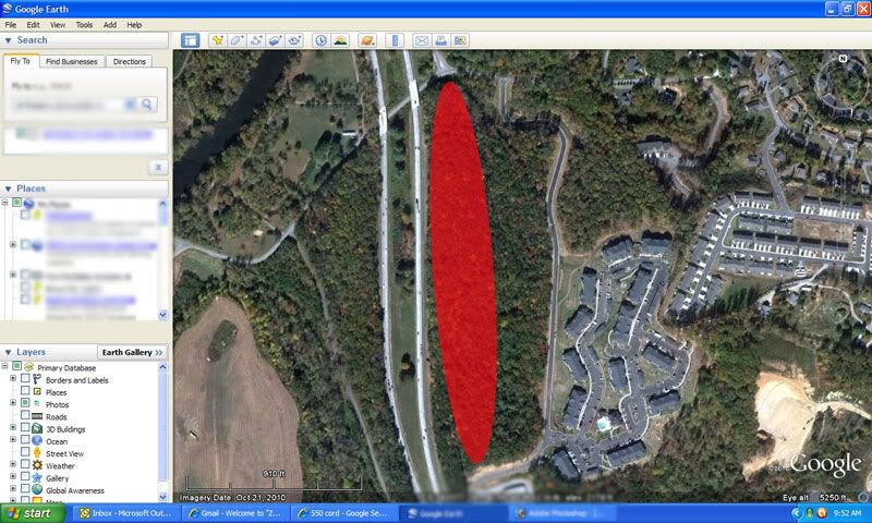
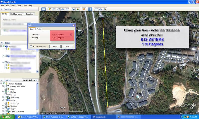
Find a location with two easily identifiable landmarks with an even distance between them. In this instance, I picked two road intersections on a plot of land near my home.
Next, use the “ruler tool” in Google Earth to plot you line. Start your line near a known point that you may easily identify. In this case, I set my start point about 20 meters in the wood line near a road intersection. My ending point is at a small clearing next to a dramatic turn in a road. The entire walk will be in the woods, with two streams and patches of dense underbrush. Now I will use the “ruler tool” in Google Earth, to see what the distance is. Lucky for me, the distance is slightly over 600 meters and the direction is parallel to a highway. I can’t get lost!To find my pace count, I would simply walk from point A to point B using my compass set at 176 degrees and record each and every step. At the end of my trip, I will then take the total number of steps and divide it by 6. That will be my average pace count for 100 meters.Example: Let’s say walking the above route takes me 755 steps total. I would simply divide 755 by 6. 755 ÷ 6 = 125.83 steps or 126 steps.The “Google” method is at the moment unproven, but I feel confident that it will work. If you do not feel comfortable using Google to find your count, you can simply run 100 meters of string in the woods and estimate your count that way. This concludes the 4th article in the “Find Your Way” series. Please check back soon where we discuss how to use landmarks to help you stay on track.Thanks and see you again soon,H-Minus
A series of articles dedicated to the lost art of land navigation and map reading
Distance and Direction
By H-Minus
You have learned how to find your location on a map by using coordinates. This article will discuss determining distance and direction on your map. To do this, we will need to look at the legend portion of our map. This section is located at the bottom of the map. The two areas of the legend we will focus on are the map scale bar and magnetic declination.
Scale Bar
Magnetic Declination
Before we start, let’s point out the cardinal directions on every topographical map. If you have a map in front of you, the top of the map will always be NORTH. The bottom will always be SOUTH. The right side of the map will always be EAST. Lastly, the left side will be WEST.
Assume you know exactly where you are on the map. You can point your finger to the exact spot on the map in front of you.
Great… you know where you are on the map and you also know where you want to go… If you look in grid square 15 – 82, you will see a symbol that looks like this:
Remember to read right and then up…..
We know where we are on the map. We know where we want to go… but… How do we get there? We need to know what direction in degrees and distance in miles, feet or meters to go. We are going to compute our distances in meters simply because when we start on the land navigation portion of our articles, we will show you how to establish a pace count to estimate distance traveled.
Let’s start with the easy part… How far is it from where you are to where you want to be? We will also assume you are going to navigate the distance as a crow might… A straight line… To figure out how far it is from point A to point B, we need only a pencil and paper.
Mark the two points on the paper and use the scale of the map to estimate the distance.
As you can see, the zero mark on this particular map scale is not quite where are points are drawn. In this case, all you need to do is use the smaller scale to the left of zero to determine the number of meters needed past 3000. In this case it is about 350 to 400 meters. Our total distance would be 3400 meters from point A to point B.
We know that our trip will be a distance of 3400 meters. Our next question is what direction we need to go to get there.
Your compass is set up in degrees.
Your protractor is also has a degree scale.
In order to establish direction you will need to first plot a line of travel. Take a straight edge and draw a line from the starting point to the destination. If the distance between point A and B are relatively close, extend your line past the destination point. This extension may be needed to help you determine direction with your protractor.
Once the line indicating direction of travel has been drawn, place the protractor squarely and centered on the map, with the crosshairs of the protractor right on top of the starting point of your line. Read the direction in degrees from the point where the line intersects the degree scale on the protractor. Just make sure your protractor is placed properly on the map. It is correctly placed if zero 0 degrees faces up, 90 degrees to the right, 180 degrees down, and 260 degrees left. The result will look like this:
This is how you establish direction in degrees on a map. There is still the issue of converting your direction from grid to magnetic. Remember, most maps have a magnetic declination and it requires a conversion from grid north to magnetic north. That difference is also measured in degrees. The legend portion at the bottom of your map will have that difference noted.
The conversion is pretty simple. It is simply a matter of adding or subtracting the G-M angle from your grid direction. The difficult part is figuring out if you have to add or subtract. That will depend on whether or not you have an easterly or westerly G-M angle.
Easterly G-M Angle
Westerly G-M Angle
There are very few things about land navigation and map reading that I have to write down. This is one of them. To make the conversions remember this:
Easterly GM angles: Grid to magnetic subtract, magnetic to grid add
Westerly GM angles: Grid to magnetic add, magnetic to grid subtract.
A good place to write this down is in permanent marker on your protractor (if you have room) or on your map case somewhere. Don’t try to remember it. In 27 years of doing and teaching this stuff, I can’t remember.
Now back to our map. Our last calculation was a grid direction of 52 degrees. Remember, that was grid degrees. We now need to know what our compass direction should be to get to point B. The legend of our map shows a 5 degree G-M angle in an easterly direction. To convert an easterly G-M angle from grid to magnetic, we must subtract the 5 Degrees from the 52 degrees plotted on the map.
52 – 5 = 47
Alright! We now know that we have a direction of 47 Degrees on our compass for 3400 meters to get to our destination.And off we go…. We are walking, looking at our compass, walking, looking at our compass, and walking… wait… how far have we gone? I don’t know. I thought you were keeping track. In fact, how do I know how many meters I have walked? That is another subject. See ya soon.
A series of articles dedicated to the lost art of land navigation and map reading
By H-Minus
I am a big fan of old westerns. John Wayne and Clint Eastwood were the quintessential cowboys. As a kid, I would imagine being on horseback in the wilderness. Me and the Duke gunning down a bad guy, wanted for some unspeakable crime… I would spend Saturday afternoons watching a drunken, U.S. Marshal and his Texas Ranger sidekick tracking the murderer of a young woman’s father. Or a Sunday Spaghetti Western, with the trio: Clint , Lee and Eli (AKA The Good, The Bad ans The Ugly) attempt to find stolen Confederate gold.
Something always bothered me about those movies… How did these guys know where to go?… There were no roads, at least not in the movies.. So how did they know what direction to travel and how did they know how to get back home?
There are some people who have a great sense of direction… I am not one of them… Even with a map and a compass, I have a difficult time getting from point “A” to point “B”.
Some of us not as directionally superior as the hero’s of those old westerns.
We need help!
The last article discussed the “Five major” and “Three minor” terrain features associated with a map. We also touched on “Grid North” versus “Magnetic North”. This article will discuss how to establish a grid coordinate as it relates to map reading.
Maps typically have one of three ways to establish a location:
Latitude and Longitude Coordinates:
The geographic latitude of a point on the Earth’s surface is the angle between the equatorial plane and a line that passes through that point and is normal to the surface of a reference ellipsoid which approximates the shape of the Earth. The North Pole is 90° N; the South Pole is 90° S. The 0° parallel of latitude is designated the equator, the fundamental plane of all geographic coordinate systems. The equator divides the globe into Northern and Southern Hemispheres.
The Longitude of a point on the Earth’s surface is the angle east or west from a reference meridian to another meridian that passes through that point. Latitude and Longitude is displayed in degrees, minutes, and seconds. To be perfectly honest with you, I know very little about longitude and latitude.
Example:
Universal Transverse Mercator (UTM):
The UTM system is a geographic coordinate grid-based method of identifying locations on the surface of the Earth. A position on the Earth is referenced in the UTM system by the UTM zone, and the easting and northing coordinate pair. The easting is the projected distance of the position eastward from the central meridian, while the northing is the projected distance of the point north from the equator (in the northern hemisphere). Eastings and northings are measured in meters. When interpreting a UTM grid you will read right (east) and up (north).
Example:
Military Grid Reference System (MGRS):
This is the standard reference for the US military and NATO. It is also the one that I am most familiar. Unfortunately, USGS maps are not marked with MGRS. MGRS is derived from the UTM (Universal Transverse Mercator) grid system, but has a different labeling as that used by UTM. A MGRS consists of three parts.
A grid zone designator, GZD. These are zones, numbered 1–60 and are intersected by latitude bands that are lettered.The intersection of a UTM zone and a latitude band is called a grid zone, whose designation in MGRS is formed by the zone number (one or two digits – the number for zones 1 to 9 is just a single digit, followed by the latitude band letter. This same notation is used in both UTM and MGRS. An example of a grid zone designator migh would be: “1Q” or 2”N”.
100,000-meter square identification. This is a lettered method of identifying a 100,000-meter square area of the earth. This is what most drunts pay attention to when goingoff map. The 100,000 – meter swuare identifyer, lets you know what the next map sheet will be. It is identified by letters. An example may be “FJ” or “AL”.
The third part of an MGRS coordinate is the numerical location within the 100,000 meter square, indicated by numbers up to a 10 digit cordinate. A ten digit cordinate will give you a potential accuracy of up to 1 meter. The fewer digits, the less the accuracy. In the case of a 10 digit cordinate, The first five digits represent the easting in meters . The second five digits would represent the northing part of the cordinate.
Example:
We will focus on UTM grid zone designators. Simply, because it is what 99 percent of us will encounter with maps originating from the USGS. You may remember from the last article that I spoke of maps that may not have grid lines marked. If you find that your map does not have grids, you can mark them with a straight edge, pencil, and steady hand. One thing to remember when reading a grid, is to always read the numbers from left to right and then up.
Example:
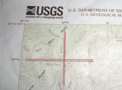
If you notice the helicopter on this map, you will see it lies within a square or grid on this map. This grid is represented by two coordinates, or sets of numbers. One set of numbers goes from left to right as seen at the top of the image. The other goes from the bottom to the top as seen on the left side of the image. These represent the northerly and easterly grid lines as discussed earlier.
You will see the number 17 3 73000 represents the easterly grid line for the helicopter. The three zeros at the end of this grid refer to 100 meter markings within that grid or box. Since we are not sure where the helicopter lies within those 100 meter boxes, we can leave the zeros off for now. We will get to those numbers as soon as we determine what grid square our helicopter lies in. So, we know that the helicopter is within the 17 3 73 easterly part of the grid, now lets determine what the northerly grid is.
Looking at the left side of the map, you will see a series of numbers going up in a northerly direction. This is the second half of your grid. In this case the helicopter lies in the 39 47 grid location.
If you put the two grid coordinates together you would have this:
17 3 73 E
39 47 W
You now have a grid location with 1000 meter accuracy, or as they say in the military “one klick”. A Klick is equal to a kilometer. Being the high speed land navers that we are, we want better accuracy than one klick. That is where our cool UTM grid tool comes in handy.
This clear plastic measuring device will help us determine a grid coordinate to at least 100 meters. You can even get accuracy to 50 meters or less by simply making an accurate guess to points falling within the little 100 meter blocks.
Once you determine the grid square coordinates, you simply duplicate the routine using the grid tool. Remember to read right and then up.
RIGHT
THEN UP
GRID
17 373650 E
39 47 400 N
Based on our calculations, we now have a grid location for the helicopter with an accuracy of at least 100 meters. It is more like 50 meters given the fact that our easterly part of the grid ends with the number 50.
That pretty much covers the basics of obtaining a grid coordinate. For those of you who like to practice, there is a fun way to incorporate this into a cool hide and seek game. Find an easily obtainable location on a map, perhaps near a known road intersection. Hide a geocache near the intersection and give the grid coordinate to friends or family. Have them do the same for you. Use your new found map reading skills to find the cache and recover the items. As you get more skilled, look for local Geocaching clubs and find more difficult caches.
I still wonder how cowboys made it around the wilderness without these tools. Were they so geographically inclined, they didn’t “need no stinkin maps?” Or was the map and compass a dirty little secret kept in saddle bags of cowboys everywhere? Well all cowboys except for Big bad John and Dirty Harry.
The Grid-Magnetic angle (or G-M angle) value is the difference between grid north and magnetic north. It is an arc, measured in degrees between the grid north and magnetic north lines. This value is measured in fractions of degrees, with mil equivalents shown to the nearest 10 mils. The G-M angle is important to land navigation because azimuths between map and ground should be adjusted to compensate for this difference. If not, you may be off by hundreds of meters before you get to where you are going. We will get more in depth on this on this in a future article.
Terrain features of a map can be difficult to understand when looking at it from a two-dimensional perspective. The best way to describe the terrain features indicated on topographical maps is to approach it the way I was taught. Features were broken down into five major and three minor terrain features.
The five major terrain features are: Hill, Ridge, Valley, Saddle, and Depression.
The three minor terrain features are: Draw, Spur and Cliff.
The best visual representation for these features is to get your map and compare the feature on the map to the actual land mass. For now, let’s look at some army training aids.
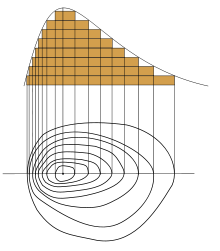
Five major terrain featuresHill: A hill represents a point of high ground with sloping features going downward. You can also observe elevation markings on the contour lines indicating the hills sloping nature.
Valley– A valley is a semi-flat piece of ground bordered on the sides by higher ground. A valley may contain a stream. The contour lines indicating a valley are U-shaped and sometimes will parallel a stream.
Ridge- A ridge is a sloping line of high ground. Contour lines forming a ridge tend to be U or V-shaped. The closed end of the contour line points away from high ground. I like to remember this when trying to determine if I am looking at a ridge or valley… “valley toward,” “ridge away.” That means the U or V is going toward the high ground on a valley and away from high ground on a ridge.
Saddle. A saddle is a dip between two areas of higher ground. A saddle is typically found between two hilltops. It can also be a dip along a ridge line. If you are standing in a saddle, you will see high ground in two opposite directions and lower ground in the other two directions.
Depression. A depression is a low point in the ground. A good example of a depression would be a quarry. I depression is pretty much a hole in the ground. On your map, a depression will show closed contour lines with tick marks pointing toward low ground.
Three minor terrain features
Draw. A draw is kind of like a small version of a valley. The exception being that in a draw, there is little or no level ground. You will likely find the draw a difficult feature to traverse. If you are standing in a draw, the ground slopes upward in three directions and downward in the other direction. A draw could be considered as the initial formation of a valley. The contour lines depicting a draw are U-shaped or V-shaped, pointing toward high ground.
Spur. A spur is a short, downward sloping line of higher ground. You will typically find a draw formation protruding from the side of a ridge line. You may also find two parallel streams flowing down the side of a ridge. These streams will often form the spur. The ground sloped down in three directions.
Cliff. A cliff is self explanatory. I am sure we all know one when we see it. When viewed on a topographical map, the contour lines will come together into one contour line; this last contour line has tick marks pointing toward low ground. Cliffs are also shown by contour lines very close together and, in some instances, touching each other. Remember each of these contour lines represent an elevation. The closer the lines are together, the more dramatic the slope.
We can go on for hours on the intricacies of maps and map reading. While writing this article, a flood of information started coming back to me from the old days. I have only touched on a very lengthy subject. If you are new to land navigation and want to know more, I would suggest you start by purchasing a USGS map of a location near you. You can pick them up at nearly all camping and hiking stores. They will also sell some of the tools needed in conjunction with your new map.
Tools for land navigation
A good compass should have at least:
A clear base plate- To see underneath the compass.
A rotating bezel, marked with 360 degrees in 2 degree increments.
Meridian lines- For map use.
Declination Adjustment and arrow- to correct for the difference between magnetic and true north
A protractor – UTM ruler:
Your protractor will need to work with 1:24,000 , 1:25,000 and 1:50,000 scale maps
It should also include a 360 degree compass rose for computing direction.
The cost is usually less than five dollars, so buying an extra is advisable.
Examples of protractors:
If you have or plan to purchase the army protractor keep in mind, it will only work with military scale maps. 1:100,000 – 1:50,000 – 1:25,000. Your USGS maps will have a different scale and coordinate scale part of the protractor will not work. The military protractor is known as GTA 5-2-12.
This concludes the first article in our series. I must add that some of the methods and tools described are simply my way of doing business. You may have or develop your own tools and tricks. That is what makes land navigation so exciting. If your way works, do it and be proud. In fact, if you have a better way of doing something, share it with the rest of us. These skills can save you life in an emergency. Keep your GPS handy, but know how to get by without it.
Technology is a wonderful tool and it gives us so much convenience and efficiency, but we can also become too dependant on it. In writing this article, evidence of our fast food society is in the very words I type. Technology allowed me to write this article without once consulting a dictionary or thesaurus. Believe me, my spelling and grammar have suffered from not picking up that dictionary.
Spell check is the devil.
Please check back for the next Find Your Way series of articles where learn how to establish grid coordinates and convert an azimuth.
Thanks and see you again soon,
H-Minus
A series of articles dedicated to the lost art of land navigation and map reading
Article 1
Introduction to maps
By H-Minus
We live in a fast food society.
I’ll bet you are wondering why I would start an article on maps and map reading with such a statement. The fact is, the term “fast food society” refers to the automated aspect of almost everything we do. This digital age we live in has made nearly everything instantly available. Smart phones bring the world to us. Email can send a message across the ocean in an instant. You no longer hear the voice of your significant other read from a map in the passenger seat of your car. It has been replaced by a pleasant British voice, or if you prefer American, saying, “in one half mile, turn left……. turn left.”Don’t get me wrong, I love the fact that things are so much easier. When it comes to land navigation, I like having my GPS. I also like the idea that should my batteries go dead, I can find my way home without it. I was taught land navigation back in 1983. I received the army version of land navigation training at Ft. Benning, Georgia. It was just enough to get me lost. I didn’t learn land navigation until I finished Jump School and was assigned to the 1st 505 Parachute Infantry regiment. Like other new troops, I was taken into the fold of the senior NCOs, all of whom were Vietnam veterans. They were some of the best teachers I have ever met. Don’t get me wrong, I can still get lost with the best of them, but I have a better chance than most of finding my way home.Cartography, or mapmaking goes back thousands of years, some say as much as 8000 years ago. A map is simply a tool to help describe and navigate an area. It can be land, sea, air and even space. Let’s stick to land. There are several types of land maps in use today. We are going to focus on topographical maps and the tools used with these maps. A topographical map is a two-dimensional representation of three-dimensional land surfaces. These maps use contour lines to show changes in elevation on a map. Contour lines have a numeric representation that refers to distance in elevation.
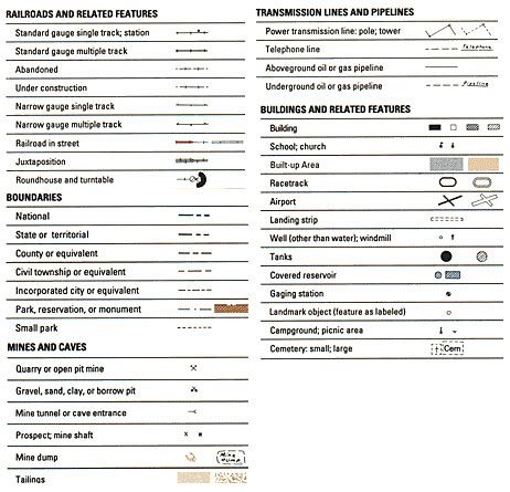
Most of the topographical maps in use today are prepared by the USGS. These maps show much more than contour lines. They contain symbols that represent buildings, airports, vegetation, cemeteries, campgrounds and much more. Different types of lines represent roads, rivers, and boundaries. In fact, there are so many symbols and lines, one can’t remember what they are without help. That is where the map legend comes in handy.
Some of the maps developed by the USGS have grid lines. Some have only grid “tic marks”. If your map has only tic marks, you can draw the lines in with a straight edge. Each of grid is marked with numbers going from left to right and up. These marks are used to determine locations on a map and convert the location to a series of numbers that represent a grid location. We will discuss how to use grids in another series.
Each topographical map will include a reference to three types of north. One is called “Grid North.” The second is called “True North” and the third is called “Magnetic North.”
Grid North – The direction of a grid line which is parallel to the central meridian on a map.
True North – The direction of a meridian of longitude that converges on the North Pole. This is just another way of saying that True North describes a direct line to the North Pole and the Earth’s spin axis.
Magnetic North – The direction indicated by a magnetic compass. This is the north that your compass will seek.
The Grid-Magnetic angle (or G-M angle) value is the difference between grid north and magnetic north. It is an arc, measured in degrees between the grid north and magnetic north lines. This value is measured in fractions of degrees, with mil equivalents shown to the nearest 10 mils. The G-M angle is important to land navigation because azimuths between map and ground should be adjusted to compensate for this difference. If not, you may be off by hundreds of meters before you get to where you are going. We will get more in depth on this on this in a future article.